Saturday, July 30, 2011

Expresso Getaway

Our last get-away was like an expresso--short but intense.  Since we've already visited the close-by attractions and our fun fund hasn't yet received our July paycheck, we opted for a one-night trip to Cedar City, about 80 miles west of Tropic.

Wednesday morning we drove to Navajo Lake and hopped on our mountain bikes.  We'd ridden the trail on the northern side of the lake two weeks ago but, without a map, couldn't find the trail on the southern shore.  This time, we were set with both map and trail description.  What a great trail--a fun ride with enough technical stuff to keep you challenged and enough dip-si-doos to keep you smiling, beautiful scenery, lovely wildflowers and perfect weather!  There was no way it could have been any better.

The volunteer at the visitor center had recommended a short hike to 'The Pinks' which started near where we parked the Jeep.  So, after riding we embarked on a hike--straight up!  The route took us to a cliff-top beneath a wall of pink hoo-doos whic looked down the Virgin River drainage and out to the peaks of Zion National Park.  Although it was a nice view, it wasn't much different from similar, more impressive ones we've see.   And we probably didn't need a strenuous hike after a 12-mile bike ride.

We drove  to Cedar City, checked in to our motel, made ourselves presentable and walked across the parking lot to Denny's, Fred's new favorite restaurant.  After dinner he returned to the room while I did a bit of shopping. 

After a morning stock-up at Walmart, we drove north to Parowan and took Route 143 to Yankee Meadows in Dixie National Forest.  We had sketchy descriptions for two trails there and picked Noah's Ark over Vermillion Castle via the eeny-meeney-miny-moe method.
The trail was 1.3 miles long and gained 1100' in elevation.  In other words, we climbed almost 100' every 1/10 mile.  Our quads, stressed by the previous day's exertion, let us know they were not happy!   The trail was steep with long drop-offs in many places and crossed talus slides in several places, making the descent more difficult than the ascent.  At the top, we had no trouble spotting Vermillion Castle but weren't sure which rocky outcrop was Noah's Ark.  On the return trip, a group heading up asked us if the view was worth the effort.  We advised them to stop at an well below the summit which provided virtually the same view.


The visitor center volunteer had suggested that we stop at Hidden Haven and walk to its two waterfalls.  This turned out to be a pleasant stroll (with no elevation change) through a lush, North Carolina-esque woods bisected by a shallow creek.  The first water fall was small and pretty;  the second was higher and cascaded into a small pool surrounded by vines, shrubs and a few yellow monkeyflowers.  A refreshing and relaxing final event in a short, busy trip.


The return route to Tropic went through Cedar Breaks NM, a beautiful place we'd visited two weeks ago--and a great spot for a quick picnic.  We found a table among tall pines on the edge of a wildflower-filled meadow to enjoy the lovely view and cool temperature.  Then it was back in the Jeep and 'home' to the RV with another work week starting in the morning.

Saturday, July 23, 2011

Three Day Get-Away

For an unknown reason, we have an extra day off this week.  We left Tropic after completing work on Tuesday and drove about 280 miles to Moab.  We hadn't expected to reach Moab in our travels because it's too far away for a two-day weekend but it's do-able with three days.

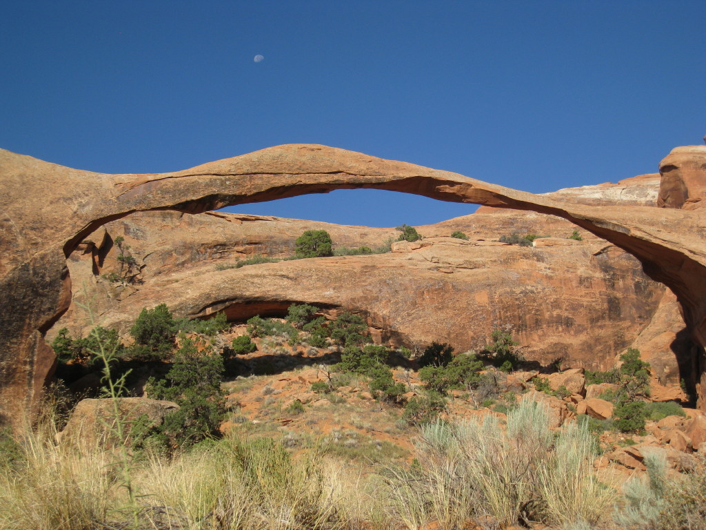
We set out for Arches National Park before 7 AM on Wednesday in order to get one of the limited parking spaces at Devil's Garden trailhead and to get in as much of our hiking as possible while it was still relatively cool.  Despite the early start, the trail was already crowded.  The first arch we saw was Landscape, the world's longest span at over 300' in length.  The 'primitive' trail beyond the arch is said to contain more arches than any other route in the park.  However, it  was unmarked and people have wandered in all directions creating social trails.  We followed one of these for about half an hour until it ended at a steep drop-off.  We attempted the loop in the opposite direction but the sand, heat and lack of arches led us to abandon that trail.

Our next objective was Delicate Arch, another extremely popular site.  Every space in the lot was occupied but a car backed out right in front of us and we scored a slot.  The longest section of the trail was uphill across slickrock and it was now mid-day--in other words, it was very, very hot.  And, like Devil's Garden, very crowded.  Our effort was rewarded with stunning views of Utah's iconic arch (it's the one on their license plates).   We drove to several overlooks and photographed some of Arches' arches, fins columns, spires and turrets.

After a nice dinner and a brief stroll around downtown, we settled in for a bit of TV.   The news led off with a report of people stranded by flooding at Delicate Arch--where we'd been only hours before!  Evidently, heavy rain had fallen to the north or east and rushed down the wash separating the parking area from the road.

Early Morning on Park Avenue,
Arches National Park

Landscape Arch

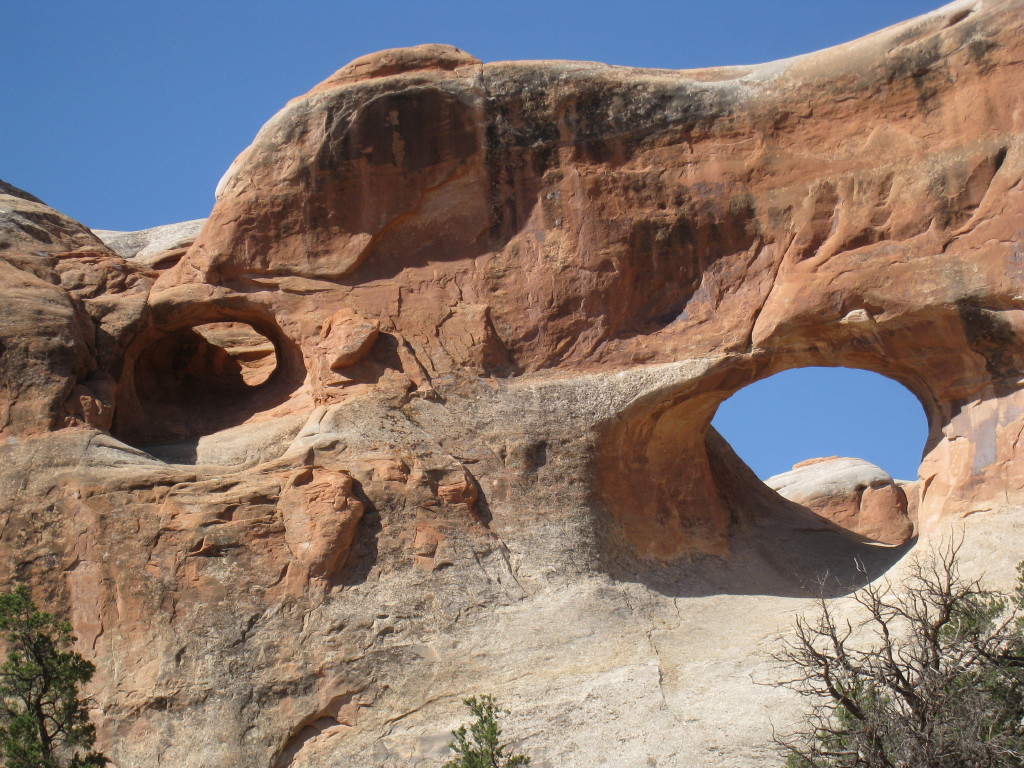
Tunnel Arch (on right) with smaller arch (left)

Double Arch
(note Fred at lower left for scale)

Can you hear the lion's roar?


Delicate Arch

Most people hear 'Moab' and think 'mountain biking' so we couldn't spend time there without trying the famous and difficult Slickrock Trail.   Even at 6:45 AM Thursday morning , we could feel the rock radiating heat.  Swooping up and down over rather steeply-sloped rock requires nerve, practice and physical conditioning.  Lacking all three, I found even the practice track too demanding. 


We returned to the motel, cleaned up, packed up and headed up to Canyonlands National Park.  Canyonlands and Arches are less than forty miles apart but completely different--Arches is all about stuff jutting out of the earth whereas Canyonlands is all about gaping abysses in the earth.  Canyonlands encompasses a vast area divided into three districts because one can't move from one to another within the park's boundaries.  Island in the Sky district, the region closest to Moab, looms between the Colorado and Green Rivers, which merge farther south in the park. 

Our hike on the Lathrop Trail meandered across the flat, dry, grassy top of the Colorado Plateau to the rim of the Colorado River's gorge.   We scrambled downward from ledge to ledge, getting impressive long-range views from a different angle after each descent.

Jan at the Grand View overlook,
Canyonlands National Park


We visited several viewpoints and ate a quick picinic before driving about sixty miles to Green River.  We'd stayed at the RV park there on the trip west  'way back in April and thought it seemed like a nice little town.  Turns out it's a crappy little town with a nice RV park.  But all we needed was a place to sleep, shower and eat; GR provided those at a minimal level. 

We decided to make the return trip on SR 24 and 12 instead of I-70 since that route is both more direct and more scenic.  Also, we could stop at Little Wild Horse Canyon and Goblin Valley State Park en route.  Little Wild Horse is a slot canyon with some extremely narrow passages, places not wide enough to put my foot down flat between the walls.  The  slot was a lot of fun to explore even though we had to forego entering the final section due to mud and standing water.

Fred in Little Wild Horse Canyon


Narrow Passage in Little Wild Horse

Standing water blocks the way through Little Wild Horse Canyon

Goblin Valley must be one of the most bizarre spots on Earth!  At the bottom of a large roughly circular basin, dark reddish-purplish-brown Entrada sandstone has eroded into weird, smooth formations that seem sculptural rather than natural.  There are no trails--you just wander where your fancy takes you among these strange shapes.  Just try not to exclaim, "Look at that one!  It looks like a........."  We were entranced for about 20 minutes before the 100* heat drew our attention away from the goblins and toward the Jeep and its air conditioner. 


Goblin Valley


The drive back to Tropic was beautiful, hot and uneventful.  The last hurrah of our vacation was a stop in Escalante for a late lunch/early dinner.   We arrived home about 4:00, worn out from cramming a week's worth of sights and activities into three days.


View from Route 12 crossing Boulder Mountain


Friday, July 15, 2011

'Break'-ing Away

We've had one of our best get-aways ever--and traveled less than 100 miles from Tropic.  The destination was Cedar Mountain, home to Cedar Breaks National Monument and a portion of Dixie National Forest.

We left Tropic at 1:00 Tuesday and mountain-biked around Navajo Lake,  a long, narrow, azure gem nestled among emerald evergreens.  The trail from the parking lot at the western end of the lake follows the rolling shoreline through the forest and then out into a lava field.  The main difficulty the trail presented was to not look at the lovely wildflowers and breath-taking scenery.
Having lost the trail description (my specialty), we couldn't find the trail on the south side of the lake so we rode the gravel road back to the parking lot.

We wanted to see Cascade Falls, created by water that seeps through the limestone beneath Navajo Lake then gushes from a small opening in the vertical cliff and tumbles several hundred feet down the mountainside.  Although it's only a mile round-trip, dark clouds, crashes of thunder and advancing sheets of rain persuaded us to return to the Jeep and get off the mountain.

On the way to our hotel, we stopped by the Renaissance Faire in a Cedar City park.  The theme wasn't very well implemented or enforced.  The connection between 'Renaissance' and 'pirates,'  'camels,' 'Mexican baskets' and 'cheap Chinese crap' was indiscernable. Nevertheless, it was interesting to see so many overweight women in too little clothing and too much make-up, men in tights and vendors of swords, chain mail, balloon animals, etc.

Tired, dirty and hungry,  our dinner destination was selected on proximity--there was a Denny's across the street from our motel.   Dinner was adequate, dessert was ooey-gooey and good! 

Wednesday morning we set out for Cedar Breaks National Monument early enough to participate in the naturalist-led wildflower hike.   While waiting for the hike to begin, we talked with a work-camper couple volunteering at CBNM for the summer.  They used to live in Highlands, NC, about 35 miles from our house!  They love CB's vistas, low visitiation numbers and its cool temps but don't have internet access at their site and have to take their RV to Cedar City to refill the propane tanks frequently.  (The high for Wed. was 53* and overnight temps still dip below freezing.)

The hike, conducted by a retired Park Sevrvice ranger, provided interesting information but fewer than hoped for wildflowers.  After an hour with the group we opted to hike the Ramparts Trail on our own.  In a two mile out-and-back, we saw wonderful wildflowers, a momma marmot and her baby, a photogenic chipmunk (who posed for pictures), stunning vistas and 1700 year-old bristlecone trees.  Although narrow in several places and steep for short stretches, the route would have been easy but for the elevation:  10, 300 feet!

In the afternoon we drove to several overlooks and wandered along the Alpine Pond trail.  It's a pretty walk though woods, across a small meadow and along a very small pond but none of these settings contained wildflowers that we hadn't seen earlier in the day.   Worn out by the elevation and the cold, we went down the mountain to Cedar City and motel #2.  After cleaning up, we ventured out on the town--found a very good Mexican restaurant, a bladder for Fred's CamelBak and a tee shirt in the exact shade I needed to match my skirt!

First on the agenda for Thursday morning was stocking up at Walmart, then up Cedar Mountain again.  With no thunderstorms in the forecast, it was safe to go to Cascade Falls.  The hike was enjoyable and the falls were impressive but nigh impossible to photograph well or accurately.  

Mammoth Cave was the last stop before returning to Stone Canyon.  This is a lava tube about 10' below ground level.  Entry is via a pit partially filled with large chunks of lava which make it possible to scramble down fairly easily.  In one direction, the floor is very smooth but the ceiling becomes lower and lower every few feet.  A person who wanted to explore further than we did has to be willing to crawl then belly-wriggle.  In the other direction, the floor is littered with large, rough lava chunks that would be difficult to cross especially in the dark.  Interesting and enough spelunking for our tastes!

With that, our fun came to an end; yesterday was back to work.  Some time ago and for some reason we can't recall, we volunteered to help with the Bryce Canyon Half-Marathon, held the 3rd Saturday in July.  Our assignment was to cut up fruit beginning at 6 AM in the little town 5 miles east of Tropic.  After enough oranges and bananas had been prepared we picked up the results sheets from the timekeepers and posted them on large bulletin boards.  We were finished by 9, in time to start our cleaning duties.  Only three more work days 'til our next getaway!


Navajo Loop Trail through Lava Fields
 
Jan on Navajo Loop Trail
Approaching Storm at Cascade Falls

Trail to Cascade Falls

One of Entrances to Mammoth Cave


Jan Enjoying Mammoth Cave
View of Zion From Cascade Falls
Momma Marmot


Cute, huh?

Obligatory Tree Picture
[1700 year-old Bristlecone Pine]


Fred on the Ramparts Trail,
Cedar Breaks National Monument


Ruby, the Brave Little Jeep


Saturday, July 9, 2011

Stay-cation

Those six days on duty while the owners attended their family reunion earned us a third day off this week:   Wednesday, Thursday and Friday--the days our friends John and Dorothy and their friends Vernon and Mary were here to hike in Bryce and other favorite destinations.

Fred selected trails for the group which showcased the variety of the features and topography and climate of this area.  Everyone claimed to enjoy the hikes in Bryce Canyon and Willis Creek slot canyon (especially afterwards!) and we enjoyed their company.  
Our Group in Willis Creek Slot Canyon

Jan, Dorothy and John at Queens Garden,
Bryce Canyon National Park

Unfortunately, Vernon aggravated a previous ankle injury; he and Mary decided to drive to Zion on Friday instead of joining us for a hike at Kodachrome State Park.  After doing the Shakespeare Arch loop, John and Dorothy wanted to see Mossy Cave and the waterfall, as per Dixie's recommendation.  (The waterfall was more robust and hence, more attractive, than when we'd seen it two months ago when merely a trickle of water passed over it.) 

Jan, Dorothy and John on Slickrock Section of Shakespear Arch Trail,
Kodachrome Basin State Park

After the hike, we said good-bye to them in the parking lot even though we both headed west--they were bound for Zion and we for the Indian store.  Five minutes after leaving Mossy Cave, we were up on the plateau watching the clouds grow ominiously darker and more threatening by the second.  Suddenly, sheets of rain rocked the Jeep, tremendous lightning bolts split the sky and thunder exploded above us.   Then it began to hail and visibility disintegrated to zero.  We were lucky enough to be near and able to discern a parking area.  For the next 20 minutes we witnessed one of Mother Nature's most awe-inspiring spectacles--lightning flashed all around us, thunder crashed overhead, rain came waves and hail covered the ground.

It seemed the storm was moving away so I asked Fred to drive me to the little building housing the pit toilets.  No sooner had I entered the ladies room than it lit up and shook as if a bomb had detonated.   Fred saw lightning strike a small pine tree about 100' away.   A  fireball appeared at its base and branches flew off the tree into the air.  Very scary!! 


We postponed the jaunt to the Indian store and came home to learn that Tropic had gotten a light shower but none of the drama we'd experienced only a few miles away.

Tuesday, July 5, 2011

More Fizzle than Sizzle

Our Fourth of July wasn't anything to write home (or a blog entry) about--even though the day started with a bang.  Actually, two booms because it's tradition in Tropic to welcome the holiday by firing a cannon at 6 AM.

We were the only workers on duty and hustled to finish in order to attend the festivities at the town park.  By the time we arrived the parade of decorated bikes was over and the bake sale wares had been sold.  There were several bounce castles, a dunk tank, an ice cream vendor and many people in lawn chairs under the shade trees. 

Since it was still early in the afternoon, we left the town park and travelled to the highest promontory you can drive to in the national park; at 9100', Rainbow Point is also the coolest spot you can reach by paved road.  We hiked part of the Rigg Springs Trail and were rewarded with some sweeping views and several uncommon wildflowers. All in all, a great way to celebrate the 4th of July
View From Rainbow Point
View From Riggs Springs Trail
Young Horned Lizard Found on Trail
Another View From Riggs Springs Trail

Monday, July 4, 2011

Saturday Night on the Town

Yesterday's workload was fairly light; we finished about noon.  Having the afternoon free and some energy in reserve was nice but temps in the upper 80s and biting insects kept us cooped up in the RV.  On the verge of cabin fever, we decided to go to Panguitch.  I'd read an article about a hot-air balloon festival there that was to conclude with illuminated balloons tethered above the main intersection at dusk.  That certainly sounded worth a 30 mile trip!

We wandered the downtown area, poking into several interesting little shops and looking for a place to eat.  The two restaurants we tried were closed and we ended up 'dining' at  Arby's, part of a gas station/convenience store.  So much for our special meal!


Unable to find the street music that was to precede the balloon illumination, we asked a shopkeeper and learned the festival was last weekend!  So much for our entertainment!

We then moved to Plan B--attend the Star Party at the national park.  We found the roped-off astronomy venue with  20-25 large telescopes behind a sign announcing the event would begin at 10:30 PM.  Since it was only 8:40, we decided to go home.  So much for star-gazing!

Even though nothing turned out as planned, it was an enjoyable evening.  And I got a picture of one of Bryce's pronghorns---obviously the one assigned to 'Saturday night near the visitor Center' duty.


Saturday, July 2, 2011

We Get the Point!

Actually, that should be:  We Got TO the Point!

Last Friday we were unable to reach Powell Point because, as a hiker told us,  the jeep road was impassable.  Without sufficient water for the 4.5 hour walk to the point and back, we decided to try at a later time.

Yesterday was a make-up day off and seemed a good time to attempt Powell Point again.  This time we took our mountain bikes, lunch and plenty of water.  Mountain biking was the ideal way to go!  Walking would have been too long, too exposed and too boring; jeeping would have been impossible due to deep mudholes and fallen trees.  The road was just pure fun to ride: dips, turns, hills, roots and rocks but nothing requiring technical moves.

About half a mile from the end, the trail became narrow, exposed and climbed steeply--too dangerous to ride.  We left the bikes and walked through a sparse forest of ancient, twisted bristlecone pines interspered with a few hardy stunted wildflowers to the terminus.  There, one stands 10,188 feet above sea level, at the very edge of one of the 'steps' which compose the Grand Staircase.  On a clear day, one can see more than 135 miles--according to the guidebooks.  Unfortunately, yesterday was rather hazy and distant vistas were quite indistinct.

On the summit we talked with the hiker we'd passed on the road.  He has explored the area extensively over a number of years and gave us his recommendations for 'must-do' hikes.

Despite the beauty of the scenery and the exhilaration of the trail, we were very happy to see our little white Jeep on the side of the road.  But even though the ride was over, we still had that 30 mile drive back to the RV.   A fun but tiring day!!