Driving from Tropic to Zion National Park took nearly three hours. We probably would have made it in 2.5 hours without the rest stop in Mt. Carmel, the wait behind an RV at the entrance gate and the delay at the long tunnel. Nevertheless, we were on the Zion shuttle bus to the Angel's Landing trailhead by 11:00.
Finding a paved trail was a surprise and led me to assume (naively!) this would be a woosey-walk. The trail zig-zags along the edge of cliffs then ascends steeply in a series of 21 switchbacks, gaining 1700' in elevation in a bit over 2 miles. The final half-mile of the hike requires one to scramble up sheer rock with occasional chains for handholds and cross a narrow unprotected saddle. I attempted the challenge but didn't feel confident about continuing beyond the second chain. Fred went further but decided not to do the saddle. Even though we didn't reach the very end of the trail, the hike was wonderful: a good work-out with stunning views and some lovely wildflowers.
 |
| Beginning the ascent. Climbing higher... |
 |
| These rocks have great variety in color, texture and direction. |
 |
| About halfway up the 21 switchbacks |
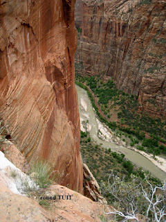
Along the way, each of us found a "round TUIT." I saw what looked like a bottlecap in one of the little openings in the rockface beside the trail. It was a quarter-size disk of aluminum, perhaps pewter, with T-U-I-T engraved on one face; hand-written on the other was the inscription, Max L. Draper, 1934-2011. I wondered if Max had wanted to hike Angel's Landing and someone saw that he got a 'round tu it' posthumously. As Fred looked at his pictures from the hike, he spotted what he thought was a quarter on a ledge several feet below the edge. Enlarging the shot, he deciphered 'T', 'U', 'I', 'T' on its surface. I checked my photos and found another in a similar location
 |
| The round TUIT is the small white dot just left of the letter 'r'. |
The remainder of our time in Zion wasn't as satisfying as Angel's Landing. We walked the Grotto Trail searching for a grotto. Turns out that's merely a creative name for the shady picnic area. Next, we elected to do the Lower Emerald Pool trail and found it was more like a big city sidewalk than a hiking trail: paved, crowded and not scenic. Emerald Pool, another fanciful name, is actually a large, shallow puddle tending more toward topaz in color than emerald. Its best feature was the abundance of shooting stars in riotous bloom.
 |
| Two small waterfalls (on left) which feed lower Emerald Pool. |
 Emerald Pool |
 Shooting Stars |
It had been a full, satisfying day and we were looking forward to concluding it with hot showers and a good dinner. When Fred turned the key in the Jeep's ignition, nothing happened. I'd forgotten to turn off the headlights after driving through the long tunnel and we had a dead battery. A park employee at the visitor center called a ranger, who appeared within 10 minutes and jump-started the car. He saw the North Carolina license plate and told us he'd done his law enforcement training in Franklin and was familiar with that part of western NC--small world!
We checked into the motel and took our luggage to the room then headed to Hurricane for dinner. We liked our meal at JB's last year so we returned for an encore and weren't disappointed. By this point in our busy day we were very tired and very hungry and very easy to please.
Wednesday morning we drove into St. George and toured Brigham Young's winter home and the Dinosaur Discovery Center; both were interesting and enjoyable. We experimented with returning by a different route: traveling north on I-15 to Cedar City then east on UT-14, north on 89 and south on UT-12. Almost as soon as we turned on to 14 big, serious snowflakes began to fall. The route would be breath-taking in good weather but its steepness, curves, lack of guardrails and warnings about ice and wildlife made it a tense drive. About halfway up Cedar Mountain a crew of DOT workers were removing a very recent a mudslide from the roadway. Next to where they were working was a mammoth boulder, about the size of a semi-tractor, which had tumbled down the hill above the road. The weather improved as soon as we crossed the summit and began to descend the eastern flank. In the Duck Creek area we saw two beavers, one stayed on the roadside while the other waddled across the road in front of us.


No comments:
Post a Comment