Wednesday, August 31, 2011

Next-to-Last-Work Day

We've written very little about working because that wasn't the focus of our being here.  It was the price we paid the piper to play, the means to an end. 

That said, there were aspects of the work that we enjoyed or found satisfying.  It gave structure to our days and led us to value our non-work time.   We felt a sense of accomplishment in turning a messy space into a neat, clean one.  (You have to close your mind to the knowledge that it will return to messiness almost immediately, needing to be redone the next day and the next day and the next....)  We enjoyed gauging our proficiency by reducing the length of time it took to 'do' a room or a cabin.  The job gave us a peek at what's involved in running a B & B as well as confirming that we lack the personalities and desire to do so!

We usually worked 2.5 to 3 hours each day, starting about 9:15 and finishing around noon.  On rare occasons a complete turn-over (cleaning all six rooms in the inn, the four cabins and the guest house) kept us busy until 1:00 or 2:00.  Every once in a while, a late check-out would delay us but there was always laundry to wash, fold or put away while we awaited their departure.

The  work required some physical strength but mainly endurance.  As we developed our own system and division of labor, it became easier.  

Fred Cleaning Inn Room Jacuzzi

Jan in One of the 5 Cabin Kitchens

Fred Checking Cabin Hot Tube pH and for Rattlesnakes


Jan Making Cabin Bed


Thursday, August 25, 2011

The Grand Finale

Our summer in Utah has been wonderful!  And our last 'weekend' was a fitting last fling. 

Within an hour of finishing work on Tuesday, we packed, made a motel reservation, gathered trail guides and headed west on Route 12 to hike the Under the Point Trail which circles the base of Powell Point.   We hiked about a mile and a half before billowing dark clouds and rumbles of thunder announced the threat of storms in the area.  Lucky for us, this first part of the route is the most scenic and we were able to see Powell Point from the bottom.   We've had views of Powell Plateau from various directions as well as the vista from its summit; this provided another, very different perspective.


Looking up to Powell Point


On the way to Escalante several serious bolts of lightning flashed nearby making us glad we'd cut the hike short.  Hoping for directions to locate the Hundred Hands Panel of pictographs (pictures or symbols painted on rock) at the Escalante River trailhead, we stopped at the visitor center.  The ranger said they are not allowed to divulge any information because the panel is sacred to the Navajo.   A borrowed trail book (thanks, Mike and Linda!) provided a few clues plus some trial-and-error led us to the panel.  A bit further along the same cliff-face are petroglyphs (pictures or symbols incised into rock) that clealy illustrate why the Navajo do not want to expose their heritage to the public. 


The Hundred Hands Panel (pictograph)


The Hundred Hands Panel is the smooth tan rectangle above
 the oval cave in the center of this photo

Petroglyph near Escalante River Trail Head


Why the Navajo don't want the location of ancient artwork revealed.
[Note petroglyphs destroyed by attempt to remove one section.]
  

After the scramble up, along and down the cliff in late afternoon heat, the Powell Point hike and the morning's work, we were tired and hungry.  The restaurant we selected for dinner was hopefully not Escalante's best.  Even though the food was disappointing, the waitress was nice and the portions were large.  But who wants lots of bad food?!

With afternoon thunderstorms forecast for Wednesday, we left early to hike 'The Box' in the Box-Death Hollow Wilderness.  The trail is 8 miles one-way and requires a shuttle; without a second vehicle, we opted for an out-and-back of the lower section.  Pine Creek, which carved the 800-1200' deep canyon, begins as spring on Boulder Mountain and becomes a main tributary of the upper Escalante River.  It is generally 6-10' wide and usually shallow enough to rock-hop across.  Thunderstorms the three previous days made the stream high and muddy and required wading to cross.  We did that 15 times in each direction!  The water felt frigid on first few crossings then refreshing as the sun rose higher. 


One of 30 crossings


In most places the canyon is wide and supports juniper, ponderosa, pinyon pine, shrubs and wildflowers; the slickrock walls and Navajo sandstone cliffs are a rainbow of buff, red, pink and white. The route basically parallels the creek but precisely where you walk is up to you and conditions at the time.  Don't feel like scrambling up that cliff?  Wade in the water.  Creek  blocked by debris?  Detour via the bank which looks most promising. 

We were enjoying ourselves so much that I wanted to suggest we do the entire trail but before I spoke, Fred pointed out dark clouds suddenly looming above the canyon walls.  In southern Utah, mornings are usually safe with the chance of thunderstorms escalating in the afternoon.  Storm clouds by 11 AM  is ominous and only the foolish ignore their potential danger.  We were back at the Jeep a few minutes past noon and, following a stop at Escalante Outfitters for drinks and their huge brownies, on the return to Tropic. 

Thad, who is not Chad, but is, like Chad, the owners' son-in-law who works at the inn, offered to take us through Round Valley Draw this morning.  We jumped at the opportunity because we'd heard it's an exceptionally beautiful, rarely visited slot canyon that requires some technical moves to descend/ascend the drop-offs. 


What an adventure!  The landscape at the 'right place' looked just like the miles and miles we'd passed to reach a nondescript wash.  Three-quarters of a mile down the wash was the entrance, a narrow slit in the ground which required stemming and butt-sliding to descend.  Once inside, we found a wonderland of colorful rock--striated, swirled, crenelated, eroded and carved into fantastical walls.  Thad is a conscientious and competent guide, giving suggestions for tackling difficult sections and providing a helping hand when necessary.  This definitely was the 'cherry on top' of our amazing Utah summer.

Entering Round Valley Draw


Thad directs Fred on descending the 16' drop
 from entry to floor of the draw


He made it!

Incredible rock walls!


Droppinjg deeper inside Round Valley Draw


Deep inside the canyon


Thad and Noah


Hiking up-canyon back to our entry point


Sunday, August 21, 2011

Hiking, HIstory and Theater

This week's adventure was probably our last overnight get-away so we wanted to make it special, hard to do since we're running out of destinations! 

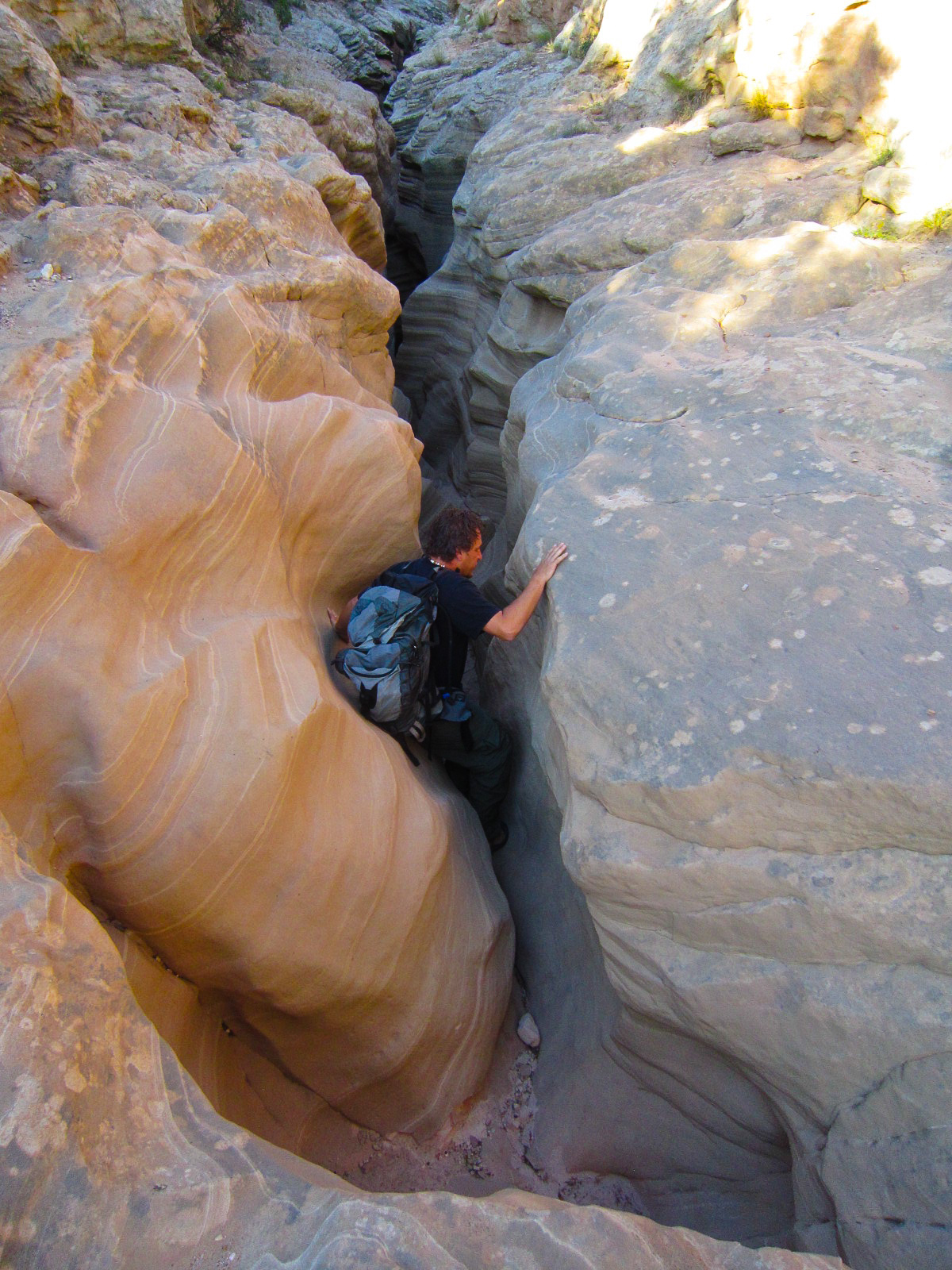
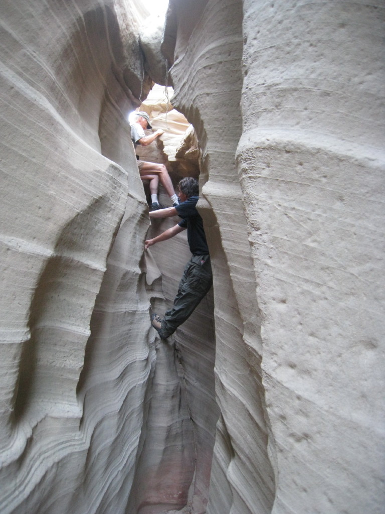
One place we hadn't visited was Kanarraville, just outside the Kolob Canyons section of Zion National Park and the access point for Spring Creek Canyon.  A shallow creek winds through this lovely slot canyon whose dark red walls provide a dramatic backdrop for abundant greenery.  Although there were a few scrambles and up-and-over detours, the hike didn't require any technical moves.  Actually, the hardest part of the endeavor was crossing 1.5 miles of scrubland to reach the canyon--hot, dry and boringly monochromatic. It wasn't a difficult six-miler but we were happy to cap it with an hour's air-conditioned drive to St. George.

Spring Creek flows out of its lush canyon
 
Fred, colorful rock and small waterfall in Spring Creek Canyon


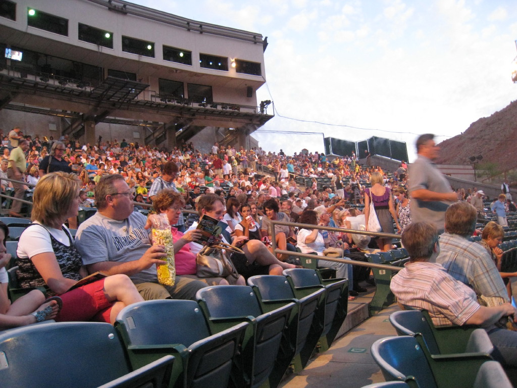
We rested a bit and then transformed ourselves from 'hikers' to 'theater-goers' for a performance of 'The Little Mermaid' at the Tuacahn Amphitheater.  This is one of St. George's gems: a grand state-of-the-art theatrical facility set in the redrock of Snow Canyon.  Sitting three rows from the stage allowed us to see how the special effects were accomplished and to enjoy the mist created by their signature water curtain.  Our only complaint was how warm it was--the night-time low for St. George was 73*, the redrock retains the day's heat and the sold-out theater seats 2000.  


Twilight at Tuacahn Amphitheater
nestled in the red rocks of Snow Canyon

Tuacahn stage's back wall is Snow Canyon


Sold-out performance of The Little Mermaid


After dinner and before the play, we finally found the upscale development of Kayenta, an expensive enviromentally-friendly development where the houses are difficult to see because they are built into the landscape and match the colors of ambient rock, lava fields and the native vegetation.  Our source had told us about a collection of artsy shops--pottery, weaving, sculpture, books, paintings, jewelry, etc.--that I wanted to investigate.  The shops closed at 5 and it was now after 7.  Nevertheless, it was a pleasant experience:  we walked through gardens interspersed with large sculptures and mobiles and indulged in some window-shopping without having to deal with other shoppers, pushy salespersons or the temptation of pricey baubles.

On Thursday morning, we went on an excellent living history tour of some of the city's historical buildings.  We met Jacob Hamblin (who discovered and named Jacob Lake on the Kaibab Plateau), Orson Pratt at the Opera House, one of the leaders of the original pioneer group  which settled St. George,  Judge MacFarland at the Court House, a Mormon woman who pushed a handcart across the Plains, losing her husband and three children between Nebraska and St. George, and Brigham Young at his winter home. 


Mormons are very proud and protective of Utah history, which is basically Mormon history.  Even though there's not that much of it--less than 200 years--what they have wrought here is impressive.   The stories are fascinating and, to Gentiles (non-Mormons), almost incredible.  I was dumb-founded to hear that Mormon teenagers voluntarily go on four-day handcart treks--crossing the desert in the summer wearing pioneer garb and pulling a heavy wood pushcart which they build themselves.
Judge MacFarland lectures the accused water-poacher


Fred and other jurors agree on a verdict of 'guilty'


Tuesday, August 16, 2011

Impromptu Exploration

Yesterday we finished work at a reasonable time and with some surplus energy so we went looking for the remnants of Tropic's predecessor, Loseeville.  The directions were pretty sketchy:  follow the road across from the pizza shop beyond BV hill til you see the old cemetery.  As soon as we crested the hill, we looked into a lush, fertile valley of irrigated fields--so different from the area surrounding the town that it seemed we'd entered another world. The old cemetery, surrounded by wire fencing, is in what's now a hay field but obviously maintained if not frequently mowed.  Loseeville was named for that family, which is well represented in the graveyard.  Further along that lane we found a retirement home for aged refrigerators and a picturesque weathered barn and corral.

Entrance to Loseeville cemetery


Frigidaire cemetery

Intrigued by the unfamiliar landscape, we traveled farther down the valley.  Soon we were beyond the irrigated land and into scrubby vegetation interspersed with shale buttes and wide, sandy washes.  Although we hadn't driven very far, we'd seen a mind-boggling variety of environments.  I guess easterners aren't used to such dramatic changes in topography occurring within the space of a mile or two.

It was so invigorating to spend an afternoon away from the RV that we extended it by climbing the hill above 'the Dump.'  This waterfall was created when the early Mormon settlers hand-dug a canal from the east fork of the Sevier River to the edge of the plateau to bring irrigation water to their fields in the valley below what's now Bryce Canyon National Park.  A short, steep climb up scree slopes to a sandstone wall of hoo-doos and windows with good views of the waterfall, into the park and out to Powell Point.

'The Dump' with Bryce Canyon National Park in the background

Through the river, up the hill--he made it to the top!

Jeep tats:


Powell Point from Loseeville:

Friday, August 12, 2011

Hurricane & Cedar City

It's becoming more difficult to find activities for our days off because we crammed so much into previous trips that few 'new' destinations remain.

The weather forecast showed a 0% chance of precipitation in southern Utah for this entire week, a safe opportunity to hike The Narrows, a slot canyon in Zion NP created by the Virgin River.  Tuesday was our fifth hard work day in a row; we wanted to leave quickly to make our time off as long as possible.  We left for Zion about 2:00 and arrived with time to hike the short Canyon Overlook trail. 

On a map, the trail looks like just a squiggle along Pine Valley Creek's canyon but it held several nice surprises.  Along about a third of the route there are seeps providing enough moisture to support maidenhair fern, rockmat, penstemon and hummingbird trumpet as well as a bit of shade and some relief from the heat.  Then there's a boardwalk built atop steel beams driven into the face of a sheer vertical cliff.  And a final short scramble over slickrock to a sweeping down-canyon view.

View From Canyon Overlook
Jan on Canyon Overlook Boardwalk


Back the trail to the Jeep, through the tunnel, a stop at the Human History Museum--attractively presented history-lite, a check on trail conditions and forecast at the visitor center, then a quick dinner and finally the motel in Hurricane.  Whew!  Busy day.

The weather report said the temp in Zion would reach 101* on Wednesday afternoon so we decided to hike the Hidden Canyon trail early in the morning and tackle The Narrows and its cold water in the heat of the day.  We had to go 3/4 mile up (500' elevation gain) the Observation Point trail in order to reach the Hidden Canyon trailhead. 

View From Observation Point Lower Trail

The route across  slickrock quickly became so narrow and angled that chains had been installed to assist  crossing safely. Turning into a sandy space between soaring rock walls, we found a sign announcing the end of the maintained trail and warning that proceeding further required major scrambling.  This was the best part of the hike--the constricted canyon was cool with lovely hanging gardens (found a variety of rattlesnake plaintain in bloom!), challenging but fun scrambles and a beautiful little free-standing arch.  Beyond the arch the scrambling required more climbing expertise than we possess so we turned around and traveled the same route out and down.

Jan on the Hidden Canyon Trail

Hidden Canyon Trail

Jan Hiking the Cliffs


Jan at the Arch


A shuttle bus soon appeared and we got a brief rest while riding to the Temple of Sinawava, departure point for The Narrows hike.  Zion is a wonderful, beautiful, amazing place; unfortunately, millions of people--many of them from Europe--have discovered that.  The mile walk to the river (on a concrete sidewalk!) was clogged with those intending to hike the river as well as those who already had and those who had come to watch.   At the end of the sidewalk, you begin the hike by crossing a 'beach' of round, smooth river rocks and wade across the river.  From then on, you are in the river whose depth varies from mid-calf on sandbars to chest-high at the first bend. 

We found walking in the river more demanding than expected--the water is cold, the current swift, the footing uncertain.  In addition, the throngs of people increased the difficulty of moving upstream and made the 4-mile round-trip to Orderville Canyon seem more punishment than pleasure.  I immersed thigh-high and Fred waist-deep before we turned back.


In The Narrows


We 'hiked' the sidewalk to the shuttle stop, rode to the parking lot, found the Jeep and drove to Cedar City for our second night away.  Long, hot showers, clean clothes, a big Mexican dinner and a DQ treat for dessert--we were happy campers!  With our hiking agenda completed, we allowed ourselves a relatively late breakfast and an interesting visit to the Pioneer Heritage Museum.  Now all that remained was a quick trip to Walmart and the gas station.  Lucky for us, the route home is astoundingly scenic so it's hard to complain about returning to Tropic.

Friday, August 5, 2011

Escalante Escapade

It's already August; the end of our four-month contract is three weeks away.  Only three more get-away trips!

This week's excursion was a one-nighter to Escalante, the next town over (if you don't count tiny Cannonville and even smaller Henrieville), 38 miles east of Tropic.  The plan for Wednesday was to leave here early, drive 26 miles on Hole-in-the-Rock road to Dry Fork then hike Spooky and Peek-a-Boo slot canyons.  Since the weatherman predicted a 40% chance of afternoon thunderstorms we aimed to return to the parking lot by noon. 


The first section of Spooky was easy although crouching under a huge chock stone wedged 3' above the floor was an unsettling reminder of the hazards in slot canyons.  Just beyond the stone, the canyon became extremely narrow.  Feeling claustrophobic, I chose to wait at the entrance while Fred penetrated further.


10 seconds, not 127 hours
 We back-tracked and spotted the entrance to Peek-a-Boo, an opening about 12' up a rock wall.  At the base of the wall sat a large puddle surrounded by slippery, sticky mud which would make climbing to the opening dangerous.  Rather than risk injury, we decided to try the up-and-over route:  hike along the side of the canyon to the top, drop over the rim, hike down to the opening and exit with a jump across the puddle.  The poorly-marked trek to the top was hard, hot and unproductive--we couldn't see the bottom at the point where dropping into the slot was feasible and a bit farther along there was standing water of unknown depth.


Muddy Entrance to Peek-a-boo
 
Tired, hungry and concerned about the building clouds, we trudged back a route which seemed longer, hotter and steeper than when we traveled it a few hours earlier.  Nevertheless, we met our goal of being out of the canyon by noon, giving us time enough time to detour to Devil's Garden.  It's a delightful pocket of fanciful rock formations:  hoo-doos, arches, windows and spires carved from vividly colored rock which we found much more accessible and engaging than Goblin Valley.  We would have explored and played there longer but those dark storm clouds were drawing ever closer.


Exit from Dry Fork

Playing in the Devil's Garden


Driving through heavy rain on a dirt road crossed by numerous washes wasn't a happy prospect and we were relieved to hit the asphalt highway about 2 PM.  Just minutes before it began to rain really, really hard.  We'd been very lucky on all counts.

We checked into a motel, cleaned up, had an adequate dinner at the restaurant next door and walked to the grocery store to purchase yogurt and fruit for breakfast.   Along the way, we revised the plan for Thursday.  Instead of a 10-mile desert hike  to another slot canyon, we selected a 5-mile out-and-back along tthe Escalante River to Phipps' Arch. 

What a great hike!  It offered a bit of everything you cold wish for:  scrambling up slickrock,  splashing through the river, bush-whacking in tall weeds, slogging through sandy washes, route-finding with GPS and topo map, spotting an eagle, wildflowers, an unusual arch and great views.  The hike turned out to be 8 miles rather than 5 and 5 hours rather than 3.5--we enjoyed each step and every minute of it.  After a quick lunch in Escalante, it was time to return to Tropic with another batch of wonderful Utah experiences.


Fred above the Escalante

Jan enjoying the Esclante River

Jan enjoying the Escalante riverbank


Phipps' Arch


Jan under Phipps' Arch

Fred above Phipps' Wash