Friday, June 17, 2011

Happy Anniversary!

We were thrilled to have June 15th and 16th as our days off this week because Thursday is our 9th wedding anniversary.   To maximize our play time, we left half an hour after finishing work on Tuesday afternoon.

We headed northeast on Utah 12, which more than lives up to its designation of ‘scenic highway’.  Our route took us from an arid desert environment to lush alpine meadows—some harboring pockets of snow!  This week’s destination was Capitol Reef National Park.   We felt that while Capitol Reef isn’t as visually stunning as Zion, it has a greater variety of terrain and coloration than Bryce.  There is an interesting historic dimension to Capitol Reef that isn't apparent in the other two Utah parks we’ve visited.
We drove the park’s Scenic Drive and the Grand Wash road, stopping frequently for photos, took a short hike and viewed the petroglyph panels.  By that time, we were tired and hungry and took the easiest option of eating at the motel’s restaurant.  The food was good but ridiculously over-priced and the service was competent but slow.

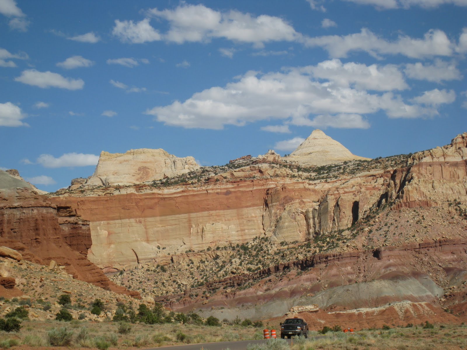
View from Route 24 Inside Capitol Reef National Park

Petroglyphs

On Wednesday we started up the trail to Navajo Knobs at 8 AM.  We knew this would be a challenging hike—10 miles over bare rock with no shade and 5800’ of elevation change—so covering as much distance as possible before the heat of the day was worth getting up early.  Our effort was rewarded with spectacular views, achy knees and a sense of accomplishment.  Being on the summit wasn't as thrilling as I'd imagined.  It was difficult to enjoy the summit's almost-360* panorma while perched on a narrow pile of unstable rock with steep drop-offs in every direction and swarms of gnats flying into noses and ears.


Jan Relaxing on Hike Up to Navajo Knobs


Jan Not Enjoying the Summit of Navajo Knobs

Before leaving the park, we visited historic Fruita.  In the 1890s, Mormon leader Brigham Young ordered one family to this difficult environment to establish an LDS presence in the area.  The community gradually grew, attaining its highest population (108) in the 1920s.  The residents found their valley, blessed with the Fremont River for irrigation and protected by sandstone cliffs, was ideal for producing fruit.  Eventually the valley floor was filled with orchards of apple, cherry, apricot, cherry, nectarine, peach, pear, plum, almond and pecan trees.  The Park Service has preserved many of the orchards, a tiny farmhouse typical of the settlement built in 1908 and occupied until 1969, several outbuildings, the picnic area and the one-room schoolhouse.

View of Fruita Farm from Rim Overlook
Our original itinerary included an anniversary dinner at the Hell's Backbone Grill Wednesday evening and hiking Upper Muley Twist Canyon on Thursday.  The effort expended on Navajo Knobs caught up with us on returning to the motel and we modified those plans:  breakfast at Hell's Backbone, a visit to Anazasi State Park and a hike to Upper Calf Creek Falls.

Thursday was just a perfect day. The meal at Hell's Backbone was delicious  (Fred--blue corn pancakes; Jan--scrambled eggs, potato cake and homemade toast)
Jan at Hells Backbone Grill

and the setting delightful; the state park, more a museum and archeological excavation site, was well-done, uncrowded and very interesting; and the 2.8 mile hike with lots of elevation change was just enough exercise for the day.  
Fred Inside Anasazi Dwelling

 Al-though Lower Calf Creek Falls is higher and more photogenic, the alcove around the pool of the Upper Falls is surrounded by yellow monkeyflower, woods rose, spiderwort and, best of all, scores of lovely stream orchids!
Trail Leading Down to Upper Calf Creek Falls

Upper Calf Creek Falls
Stream Orchid at Bottom of Falls
Alcove at Bottom of Falls

Obligatory Tree Picture
We truly had a happy anniversary and a great mini-vacation.

Saturday, June 11, 2011

Catch-up Post

 We returned from our trip to Zion and Cedar City on Tuesday afternoon and went back to work on Wednesday morning.  The workload hasn't been killer even though Chad and Marci, the housekeeping honchos, are at a gun and knife show in Atlanta from Thursday through Monday..

Thursday was wildlife day.  A pinyon jay and several chipmunks visited the birdfeeder in early morning.  Later on, a mule deer came quite close to the RV without exhibiting any apparent fear.  As we set out for a late afternoon run and had gone about 30 steps from the RV, we saw a young rattlesnake slither across the lane heading in the general direction of our site.  That cast a whole new perspective on 'just taking a walk around the property'! We'll hack down the weeds near the RV which might provide cover and may even put away the birdfeeder.

Today is "the wedding" which has had things here in an uproar.  The actual ceremony will take place tomorrow in the national park with a reception at the lodge there.  The shindig this evening is an informal dinner for 25.  The inn isn't set up for large groups or food service for more than 12 people so it will be...interesting.  We'll cover check-ins and the desk while the owners and the other work-kampers handle the guests.

Yesterday we finished our duties about noon and went to Bryce.  We couldn't hike the trail we'd selected because the parking lot was like the mall at Christmas.  Instead, we decided to try Swamp Canyon loop.  With only the information provided by the Park Service (inaccurate/vague), we couldn't find the second half of the loop so we made it an out-and-back. 
We went from the top of the Paunsaugunt Plateau to the floor of the canyon (750' of elevation change in each direction) and saw hoodoos, cliffs, a momma pronghorn deer with her three (!) tiny fawns, forests, a lovely little stream and many varieties of wildfowers.


On the way back to Tropic we stopped along the wash (seasonal river course, now bone-dry) to photograph an old pick-up truck and sun-bleached wooden wagon.  You never know what you'll find out here in the wilds of the West!


Thursday, June 9, 2011

Parowan Gap Petroglyphs--Old & New

Our 'weekend' plans were designed around the need to purchase and mail the external hard-drive and to restock our larder at WalMart.  A visit to the Parowan Gap petroglyph panels about 15 miles outside Cedar City, briefly mentioned in a tourist brochure, seemed like an interesting activity for Tuesday morning.

Although the directions were sketchy, the site was easy to reach and well worth the trip.  Archeologists have counted over 1500 figures, some nearly 5000 years old, scattered over 90 panels on both sides of a 600-foot deep notch in the hills surrounding Cedar Valley.  What makes the site so unusual, aside from the number of figures and span of time during which they were created, is that the Gap was used by the Paleo-Indians as a solar calendar.  The main glyph, nicknamed "The Zipper", may record the sun's movement through the Gap in order to schedule planting and harvesting times.

Zipper Petroglyph


Earlier visitors to the site have felt compelled to add modern graffiti to the ancient.   Thus, chainlink fencing has been erected around several panels to protect them from further damage or theft.  (Yes, people have pried off slabs of petroglyphs!) .  The necessity of the barrier is apparent but regretable because the direct and bright light (it's a solar calendar, after all) makes photography difficult.


On the way back across Cedar Valley, we saw a long white line moving across the horizon.  As we drew closer, we discerned a shepherd on horseback moving a huge herd of ~300 sheep from one side of the road to the other.  Cool!

Wednesday, June 8, 2011

It Just Makes You Wonder...

OK, we're bound  for Zion's Observation Point--4 miles and 2147' above us.  The trail ascends in a continuous series of switchbacks along the wall of Zion Canyon.  Although narrow and steep, the route offers astounding views and, at this time of year, wonderful wildflowers.  Our favorite section was the stretch through Echo Canyon, where the trail hugs the wall.  At various points, you can peer over the edge of the trail and look down, down, down into this hanging slot canyon but not see the bottom.

Our guidebook describes the last part of the ascent as 'airy'.   We didn't understand that adjective until we reached the "final ascent across white cliffs that drop away for a thousand feet below the pathway."  At that point, we learned that 'airy' means  'trying to move forward along a narrow ledge in the face of 60 mph head-winds.'  We literally clung to the wall, pulling ourselves along and attempting to shield our faces from the stinging blowing sand. 

Fortunately, the wind was less intense on the plateau at the summit--or so we thought.  When we rounded a turn, we saw a young woman sitting on the ground holding a bloody cloth to a wound on her head.  The wind had blown down a heavy 25' dead bristlecone pine on her as she passed by!  Although injured, she was very lucky not to have taken a more direct hit or been knocked off the precipice.  'Whew!,' we thought, 'That's two bullets (the wind and the tree) we've dodged today.' 

As we headed for the point, hikers warned us to watch out for the rattlesnake.  Yep, there he was, slithering his whole four-foot length under a tree toward a patch of shade.  Fred took several pictures and we proceeded to find a spot for lunch.  Suddenly, we noticed Mr. Rattler-- about six feet away and wending his reptilian way right for us.  Ours was a movable feast so we hastily relocated. When I commented to Fred that we'd done a tough eight miles, he told me we'd only done four miles at that point.  But we'd certainly had 8 miles worth of thrills and chills.

Our descent was faster and less eventful--until we were about a mile from the trailhead.  I stopped to snap a wildlfower while Fred continued on and was about 15' ahead of me.  At the same instant, we both heard a rumble above us and knew it was a rock fall.  But the sheerness of the cliffs and vegetation hid the source.  Then a basketball-size rock crashed on the trail between us and continued bouncing downward.

Although Observation Point had been a great hike with breath-taking vistas and beautiful wildflowers, we were glad to complete it unscathed, i.e., not blown off the trail, clobbered by a tree, bitten by a snake or smashed by a rock.


Tuesday, June 7, 2011

The Week That Was...

I haven't put up a post in a while so to catch up... 

Since our TV lost its video capability (about two weeks ago), we've been viewing DVDs on my computer.  Thursday evening, we watched "Unstoppable"; on Friday morning, the computer refused to boot up.  (Thanks, NetFlix!)  Long story short, in the process of trying to get the machine to restart, we had to revert to 'restore factory settings'.  The computer opened but my files had disappeared--pictures of family, trips, events and all the wildflowers I've photographed and identified, documents, reference websites, etc.  Fred consulted with daughter Alissa and her husband, both super computer-savvy, and they generously offered to search the hard drive and restore the files.  We need to copy the hard drive onto an external unit and mail it to them.
Purchasing an external hard-drive became the priority for our up-coming days off.

It had been a tough, frustrating work-week and we wanted to maximize our time off by spending as much time off-site as possible.  Now we had a plan:  Get away and buy a hard-drive!  In other words, head for St. George as soon as we finished our duties on Sunday. 

We left Tropic at 2:00, found the Best Buy, purchased the hard-drive and checked into our motel in Hurricane by 6:00.  Priorities #1 and #2 accomplished, we then focused on f-u-n.  The kick-off event was dinner at JB's, a family-style restaurant with wonderful food, large portions, reasonable prices and nice waitresses.

Early Monday morning we gassed up the Jeep ($3.63/gal--yay!), bought some goodies for lunch, picked up a mailing box at the post office and drove 30 miles to Zion.  Found a shady parking space and seats on the shuttle and were on the trail to Observation Point by 10.

Our Day to Take It Easy (you know better!)

June 1, 2011

Just like yestereday, today started off with a leak.  We thought we'd corrected the problem but  I felt the spot where we'd first noticed dampness and it was wet again.  Fred thinks that he inadvertently jiggled a fitting while trying to fix yesterday's leak.  He tightened the fitting before we left and the area was still dry when we returned.

Yesterday's hike took a lot out of us for some reason and we agreed not to hike a long distance or with much difficulty today.  The plan was to drive to an area of hoodoos, wander around and take pictures.  When we stopped at the GSENM visitor center (it's always recommended to do that to find out about the possibility of flash floods), the ranger uttered those magic words Fred can't resist:  slot canyon.  He told me it was an easy 2.5 miler.  He didn't tell me:  that was the distance one-way, that it entailed climbing, stemming and using ropes and that we'd left the map and GPS in the RV. 

Long short short:  the route was hot and sandy but there were some great wildflowers and amazing rock colors and formations.  When we reached the slot canyon, its bottom was covered with water of unknown depth about 50' from the entrance.  So, with great relief on my part, we turned around.

We stopped at a funky little restaurant/outfitter/souvenir shop our Pisgah Forest neighbors had recommended highly.  The menu was interesting and much nicer than our waitress.  We'll spend what's left of the day relaxing and preparing to return to work tomorrow.

Wednesday, June 1, 2011

A Full Day

Yesterday was our first day off after a long, hard week.  We were lucky with perfect hiking weather yet again--clear skies, comfortable temps and a nice breeze  Our plan was to go to Panguitch to deposit our paycheck, come home and go hike.

When I picked up the bathrobe that had fallen off the bed during the night, it was wet??  After a good deal of searching and speculating, we isolated the location of the source--at the end of the bed, behind the difficult-to-remove drawers, at the back of a crawlspace.  Fred compressed and contorted himself enough to inspect the water-lines and connections; none were leaking.  He thought the most likely cause was the absence of a silicone seal under the faucet housing in the shower.  Easy enough to remedy but the task ate up about two hours of our precious free time.

Next--on to Panguitch!  With four times the population of Tropic, we expected their (one and only) grocery store to have a larger selection and lower prices.  Wrong on both counts!  Since we had no intention of spending the day bargain-hunting, we bought a few necessities, returned home and packed up for Kodakchrome Basin State Park.

We'd hiked the park's longest trail on a visit early in May.  Today's agenda was to 'finish up' Kodakchrome by doing Shakespeare Arch, Angel's Palace and the Grand Parade, the three trails totaling about 6.5 miles.  (I offer no explanation for the fanciful names--nothing about any of them merited the label applied.)  Although they weren't far from one another, each route was quite distinct--interesting and beautiful in its own way. 

Shakespeare Arch passes the park's only large arch as it skirts the rim of Kodakchrome Basin and offers breath-taking views of the surrounding Grand Staircase-Escalante National Monument.  We took the challenging alternate route that required a brief but steep stretch across slickrock--fun! Lots of evening-primroses.


Shakespeare Arch

The Grand Staircase in the distance


Fred at The Sentinel

 Angel's Palace climbs a small plateau and projects on to fingers above the Basin. There are sweeping views of the Basin and Bryce Canyon.  Lots of sego lilies.


Sego Lily


Kodachrome's red rock spires from Angel's Palace

Brave Fred out on one of the projections 150' above the Basin's floor

Obligatory Tree Picture

The Grand Parade stays on the floor of the Basin, hugging the base of cliffs rising above.  We took a side-trip into a box canyon that was unremarkable.


Red rocks, hoodoos and spires

Can you see the two figures?  
This immediaely reminded me of Hammurabi's Stele.

Mother Nature's diorama

We returned home tired, dusty, hungry and with memory-cards full of (hopefully) wonderful photos!

Sunday, May 29, 2011

Eventful, but not in a good way

We knew, by looking at the schedule, that yesterday would bring a heavy workload—three cottages and three rooms to be cleaned, three rooms to be serviced, the common areas to be dusted and vacuumed plus mountains of laundry to be washed, dried, folded and put away.  Earlier in the week, we volunteered for check-in duty, manning the registration desk from 3-8, because that would be a good opportunity to do our personal laundry.

We completed our housekeeping duties at 12:30; however, before we could return to the RV for lunch, showers and time to relax, the owner informed us that she had OK’d an early check-in, expected between 1:00 and 2:00.  Fred stayed at the inn while I ran home to shower then we traded places.  Our ‘early check-in’ drifted in at 5:15 (forced smile) and the other new guests appeared by 8:00.  Tired and hungry, we loaded the Jeep with our clean clothes and headed up the lane to ‘home.’

Less than 10 minutes later, a guest called, saying her husband was having a medical emergency; could we please get help for him?  We dialed 911 and drove back to the inn.

Bob, her 73-year old husband, was propped up on the sofa in the common area animatedly telling two couples what happened:  he and his wife were having wine on the deck when his speech became garbled and his right side got weak.

Less than ten minutes after the 911 call, EMTs* arrived followed by the ambulance and its crew.  They took his blood pressure, tested his blood sugar, did an EKG, administered a battery of quick-and-dirty stroke screenings and determined he needed to be examined more thoroughly at the nearest hospital, 30 miles away in Panguitch.

His wife was understandably upset and flustered.  She wanted to be with him but she was frightened to drive to the hospital in the dark because she’d never seen the route or driven her husband’s SUV.  We volunteered to have Fred drive her in their vehicle and me follow in the Jeep--she could stay with her husband and Fred would have a way home.

The hospital staff attended to Bob immediately.  In less than 45 minutes, the doctor was able to tell us Bob suffered a TIA or mini-stroke and needed to be observed for the next 12 hours.  Bob stayed in the hospital, Fred and Bernie in the SUV and I in the Jeep returned to Stone Canyon.  It was 11:37 PM when we completed our day’s work.

*[When Dixie had told us that everyone in Tropic is an EMT, I thought she was exaggerating.  If she was, it wasn’t by much!  At least a dozen people responded to the emergency.  We were impressed by and appreciative of their calm, compassionate and competent treatment of a couple in an unfamiliar place among strangers who were thrust into a frightening situation.]